The San Diego Seismic Safety Study
The San Diego Seismic Safety Study is a series of maps that indicate the likely geologic hazards throughout the city. These maps may be used to evaluate the relative risk within a region or to determine if a geotechnical report is required for development or building permits.
These maps do not furnish site specific information and should be used only as a guide when evaluating risk. They are intended to be an indicator of what to expect at your site and provide general geologic hazard information.
Please note that the California Department of Conservation continuously updates the Alquist-Priolo Earthquake Fault Zones (City of San Diego - Geologic Hazard Category 11) within the State of California. For the most up-to-date limits of the Alquist-Priolo Earthquake Fault Zone refer to the following:
Earthquake Hazard Zone app EQZapp Map:
https://www.conservation.ca.gov/cgs/geohazards/eq-zapp
Geologic Hazards and Faults Maps
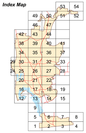
Click a grid tile on the map below. After the PDF opens, you can zoom in to find a specific parcel and print a close-up view.
- Grid 1
- Grid 2
- Grid 3
- Grid 4
- Grid 5
- Grid 6
- Grid 7
- Grid 8
- Grid 9
- Grid 12
- Grid 13
- Grid 14
- Grid 15
- Grid 16
- Grid 17
- Grid 18
- Grid 19
- Grid 20
- Grid 21
- Grid 22
- Grid 24
- Grid 25
- Grid 26
- Grid 27
- Grid 28
- Grid 29
- Grid 30
- Grid 31
- Grid 32
- Grid 33
- Grid 34
- Grid 35
- Grid 36
- Grid 37
- Grid 38
- Grid 39
- Grid 40
- Grid 41
- Grid 42
- Grid 43
- Grid 44
- Grid 46
- Grid 47
- Grid 49
- Grid 50
- Grid 51
- Grid 52
- Grid 53
- Grid 54