


Diamond Street Traffic Calming Project in Pacific Beach
Diamond Street Traffic Calming further enhances the PB Pathway, which is helping to create a network of multimodal travel enhancements throughout Pacific Beach.
The project is a type of Quick Build, where materials are easily installed and modified as necessary in response to any changes or issues that may arise. The flexible posts are designed to allow access for emergency vehicles, so response times will not be impacted.
Reference materials on the safe use of the new road conditions have been distributed to residents, school families and churches along Diamond Street. This animated video demonstrates how the intersections function.
This project provides a safer space for people to walk/roll, bike/handcycle, skate or scooter on Diamond Street between Ingraham Street (Pacific Beach Middle School and Pacific Beach Recreation Center) and Mission Boulevard (beach, boardwalk and businesses).
Project Details
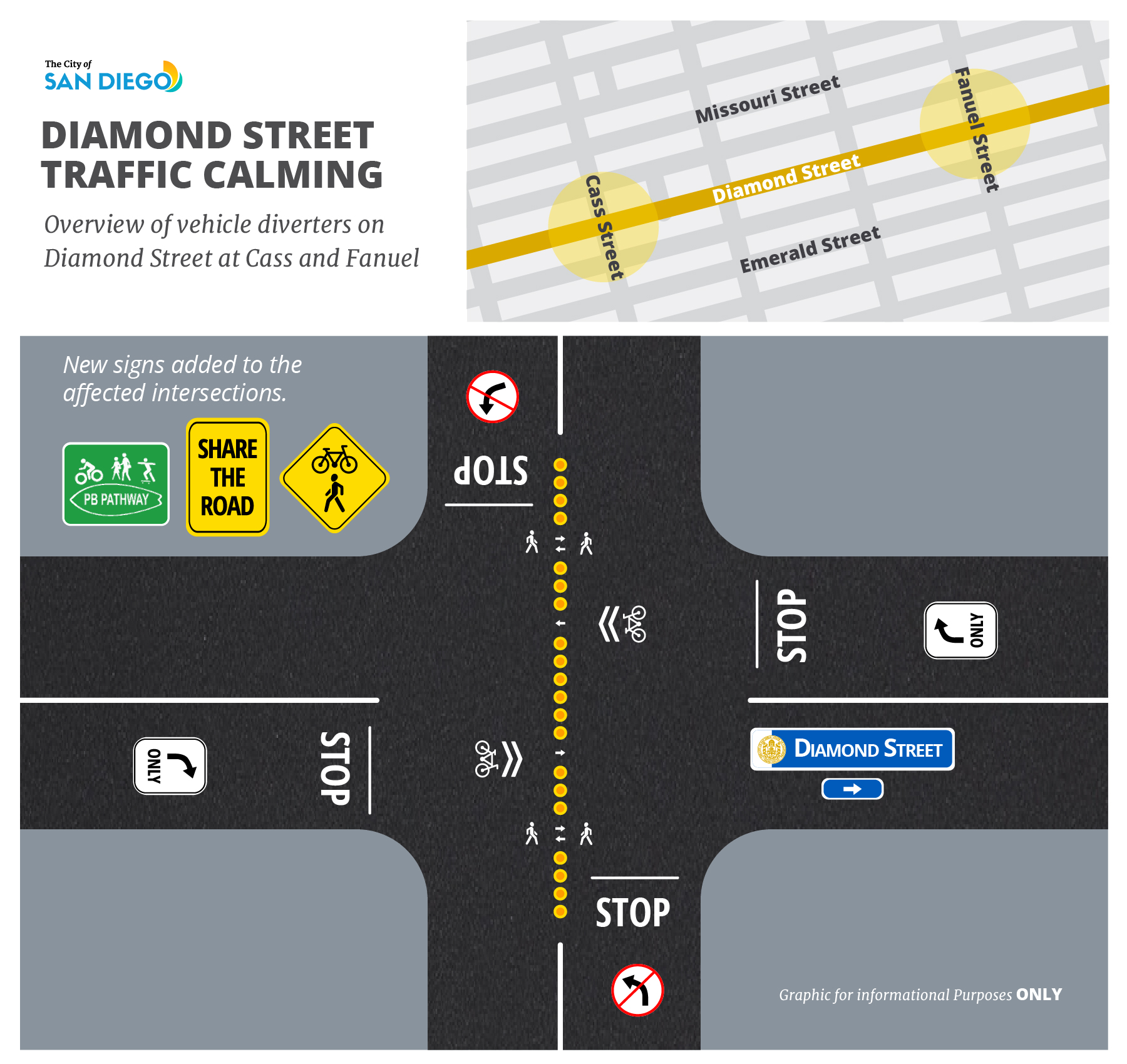
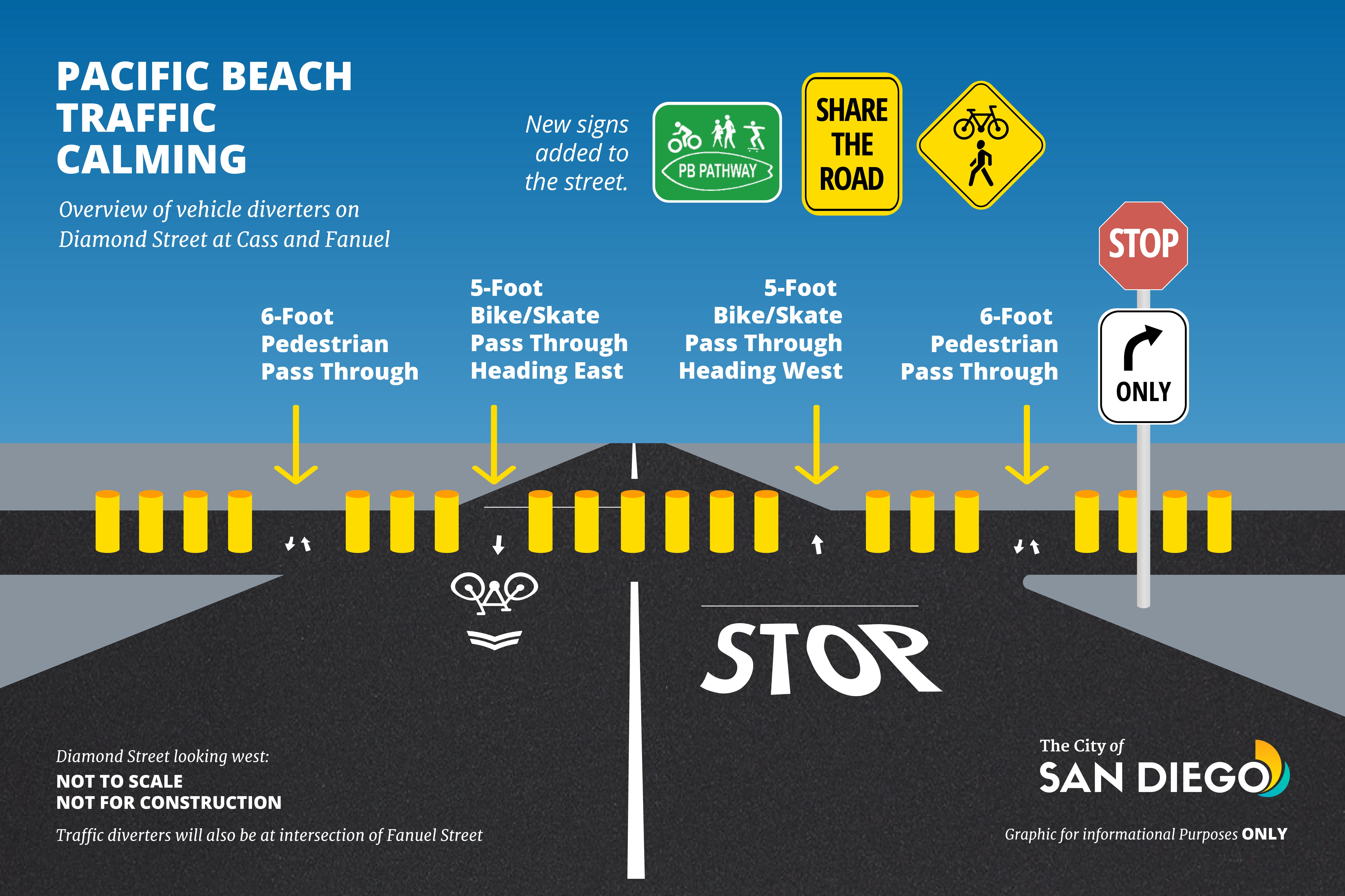
Vehicular traffic diverters have been installed at two intersections, with additional street signage along the corridor between Ingraham Street and Mission Boulevard.
Specifically, the project includes the installation of flexible posts and directional turn signage at Cass and Fanuel Streets:
- The posts have pass-throughs for users of all ages and abilities, including pedestrians at the curb ramps, and cyclists and shared mobility device users through the middle.
- Drivers of cars can turn right at these intersections, or start a different route at Ingraham, such as Garnet Avenue, or from neighborhood access at another residential street.
Benefits
- Supports Vision Zero goals by slowing the speed of cars and improving safety for people of all ages and abilities.
- Encourages San Diegans to use less-polluting modes of transportation, such as walking/rolling, bicycling, and using scooters.
- Supports the City’s Climate Action Plan, Strategy 3: Mobility and Land Use.
- Creates a pathway and connection for youth attending Pacific Beach Middle School, encouraging biking and walking to and from school to reduce congestion experienced during those times.
Background
This traffic calming project builds off the PB Pathway system, a community-driven effort that was started in 2015. Decals and signage are located along the first phase of roadways within the community, funded by Beautiful PB. Subsequently, Diamond Street was used as a “Slow Streets” pilot during the COVID-19 pandemic.
Through a series of meetings between 2021 and 2023, the City has heard ideas from the community on a future phase of the Diamond Street Slow Street. City Transportation engineering staff worked to align the Slow Street functionality experienced during COVID-19 and the community input for design ideas with federal and state engineering design requirements and guidelines.
The proposed Quick Build design was identified as an opportunity to continue to elevate the use of alternative ways to get around Pacific Beach, implement new techniques to address Vision Zero, and create a community connection building on the PB Pathway.
Groups such as beautifulPB, Circulate San Diego and San Diego County Bicycling Coalition - and events like CicloSDias, weekly running clubs, and demonstration pop-ups - have also helped to communicate the opportunities and benefits of traffic calming and have allowed Pacific Beach residents to provide their feedback.