City Seal The City of San Diego
HomeContact the City
City Seal
City Seal Business City Hall Community Departments Information Leisure Services A-Z Visiting
Planning Department
Planning Department HomeAbout UsPrograms & ProjectsGeneral PlanCommunity PlanningBoards & CommissionsGet InvolvedDocument LibrarySite Map
Community Profiles
Photo of Community Neighborhood
  San Diego Community Profile: East Elliott
 

Community Planning Quick Links

• Overview & Background
• Community Planning Groups (CPG)
•  Community Planning Groups Contact List (CPG) (PDF: 243K)
• Community Planners Committee (CPC)
• Community/Land Use Plans
•  Community Orientation Workshop (COW)
• Community Profiles
• Get Involved in Your Community
• Other Community Planning Resources
• Community Planning Home


Go Button

Don't know what community you are in? View General Community Map

 East Elliott Community Links
•  Community Planning Group Agendas
• Community Planning Group Info (PDF: 143K)
• Community Contact Information
• Demographic Information (PDF)
•  Parks & Other Community Services
• Maps

 Planning Programs
• General Plan & Community Plans
City of Villages Strategy for Smart Growth
• Multiple Species Conservation Program
Protecting Our Environment
• Historical Resources
Protecting Our Rich Cultural Heritage
• Facilities Financing
Long range fiscal planning for public facilities
• Transportation Planning
Enhancing Mobility in San Diego
• Maps & Urban Analysis
Statistics & Customized Maps for Our Communities
• Document Library
Quick Access to Planning Re-Draft & Docketed Items

Community Area: Central

Photo of Open Space Bounded by Miramar Marine Corps Air Station to the north and west, SR-52 and Mast Boulevard to the south, and the city of Santee to the east, East Elliott is a portion of former Camp Elliott, purchased by the United States Government in 1941 for use as a Marine Corps training camp. In 1961, approximately half of Camp Elliott-including present day East Elliott, Tierrasanta, and a portion of Mission Trails Regional Park--was declared surplus and sold. The 1962 Elliott Community Plan applicable to this area was updated in 1971, and in 1982 a separate community plan for Tierrasanta was adopted.

In 1997, the Multiple Species Conservation Program identified the majority of East Elliott as Multiple Habitat Planning Area (MHPA), where preservation of the natural habitat would be pursued. The East Elliott Community Plan (PDF: 743K) was amended at that time to designate the MHPA as open space. Areas outside of the MHPA include the 474 acre Sycamore Landfill; a 117 acre area bordering the city of Santee, which was designated for low density residential development; and an 8 acre area at SR-52 and Mast Boulevard, designated for office use. The community plan was amended in April 2002 to add aggregate processing as a permitted use at Sycamore Landfill, and a long range master plan is currently under review for the landfill.

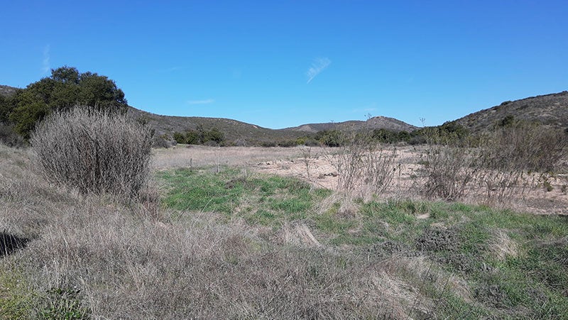
East Elliott remains undeveloped, with the only uses being the Sycamore Landfill and a few telecommunication antennas. It is dominated by native vegetation, including sage scrub, chaparral, native grassland, and oak and sycamore woodland. It constitutes one of the largest and biologically most important remaining open space areas in San Diego with a number of endangered and threatened wildlife species.

Additional Plan Documents


Contact City Planning & Community Investment at (619) 235-5200 or e-mail us at planning@sandiego.gov
202 C Street, MS 4A, San Diego, CA 92101

| Planning Department Home | About Us | Programs & Projects | General Plan | Top of Page |
| Community Planning | Boards & Commissions | Get Involved | Document Library | Site Map |
Site Map Privacy Notice Disclaimers