City Seal The City of San Diego
HomeContact the City
City Seal
City Seal Business City Hall Community Departments Information Leisure Services A-Z Visiting
Planning Department
Planning Department HomeAbout UsPrograms & ProjectsGeneral PlanCommunity PlanningBoards & CommissionsGet InvolvedDocument LibrarySite Map
Community Profiles
Photo of Community Neighborhood
  San Diego Community Profile: Kensington-Talmadge
 

Community Planning Quick Links

• Overview & Background
• Community Planning Groups (CPG)
•  Community Planning Groups Contact List (CPG) (PDF: 243K)
• Community Planners Committee (CPC)
• Community/Land Use Plans
•  Community Orientation Workshop (COW)
•  Electronic Community Orientation Workshop (E-COW)
• Community Profiles
• Get Involved in Your Community
• Other Community Planning Resources
• Community Planning Home


Go Button

Don't know what community you are in? View General Community Map

 Kensington-Talmadge Community Links
•  Community Planning Group Agendas
• Current Community Plan
• Community Planning Group Info (PDF: 143K)
• Community Contact Information
• Demographic Information (PDF)
•  Parks & Other Community Services
• Maps
• Existing Conditions

 Planning Programs
• General Plan & Community Plans
City of Villages Strategy for Smart Growth
• Multiple Species Conservation Program
Protecting Our Environment
• Historical Resources
Protecting Our Rich Cultural Heritage
• Facilities Financing
Long range fiscal planning for public facilities
• Transportation Planning
Enhancing Mobility in San Diego
• Maps & Urban Analysis
Statistics & Customized Maps for Our Communities
• Document Library
Quick Access to Planning Re-Draft & Docketed Items

Community Area: Central Urbanized

Photo of Kensington The Kensington-Talmadge Community lies south of Highway 8, east of Interstate 15, west of Collwood Boulevard and north of El Cajon Boulevard.

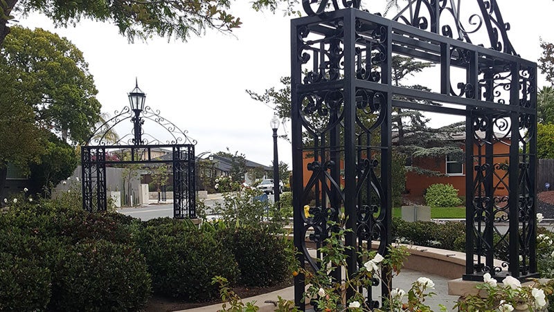
Kensington is named for a borough in London, England, and its pioneering subdivision dates back to 1910. Developers designed this unique neighborhood based on its geography and the non-standard layout due to its location on a narrow peninsula isolated on three sides by steep slopes, much of which is dedicated open space. Kensington offers a miniature "Main Street" along Adams Avenue, replete with coffee shops, restaurants, a branch library and the regionally famous Ken Theatre. With its stone gateways, ornamental lighting, and curving streets, the neighborhood is a strong candidate for designation as a historical district.

Talmadge was established in 1925 by real estate developers Roy and Guy Lichty. Talmadge was named after Norma Talmadge and her sisters, Constance and Natalie. The three sisters were noted silent film stars. It's a special hidden neighborhood, which is the cousin of Kensington and surrounded by beautiful canyons. Today, Talmadge is comprised of a mixture of single-family homes and mid- to large apartment complexes. Talmadge is also home to the Talmadge Gates Historical District.
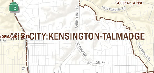
 Talmadge has a Maintenance Assessment District (TMAD) for the purpose of improving the public right-of-way with landscaping, ornamental lighting and traffic calming devices. TMAD was voted by the residents into effect and approved by the City Council in 2001. As part of this beautification effort, Talmadge has planted more than 400 trees along its streets and drives during 2001 and 2002.


Contact Planning at (619) 235-5200 or e-mail us at planning@sandiego.gov
202 C Street, MS 4A
San Diego, CA 92101

| Planning Department Home | About Us | Programs & Projects | General Plan | Top of Page |
| Community Planning | Boards & Commissions | Get Involved | Document Library | Site Map |
Site Map Privacy Notice Disclaimers