Flooding
What does science tell us?
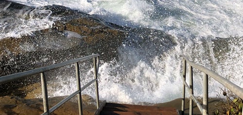
Climate change is expected to drive more variability in rainfall from year to year and more intense transitions between droughts and flood events. Some areas of San Diego already flood when there are heavy rainfall events. As rainfall events become stronger in the future, the areas affected by flooding are projected to increase.
What is the City doing?
- Flood Insurance Rate Map - Flood Insurance Rate Maps (FIRMs) are issued by the Federal Emergency Management Agency (FEMA) and show the level of flood risk in your community. Visit https://msc.fema.gov to find the flood risk in your area.
- National Flood Insurance Program - The City participates in the National Flood Insurance Program (NFIP), which provides subsidized flood insurance for property owners in flood‑risk areas. The City also participates in the Federal Community Rating System (CRS), allowing all property owners and renters to receive an automatic 15% discount on their NFIP flood insurance premiums. Visit www.floodsmart.gov to find an NFIP flood insurance provider.
- Municipal Waterways Maintenance Plan - This plan guides maintenance of the storm drain system to protect life and property from potential flooding.
- Watershed Asset Management Plan - This plan identifies the investments needed to maintain the City's stormwater management system for flood risk management and stormwater quality.
What can you do?
Climate change drives more variability in our rainfall patterns, meaning more intense transitions between droughts and rain events, and more intense rainfall when we do receive it. Rainstorms with greater precipitation over a shorter period of time can increase flood risk and occurrence.
Heavy rainfall can cause flooding of roadways and create safety hazards. Heavy rains are a signal to be aware and check for flooding conditions. Remember never to drive your car into water of unknown depths and stay out of flooding areas. Water can rise quickly and may be moving more rapidly and powerfully than you can see.
- Consider ways to protect your home from flooding.
- Learn more about storm preparedness.
- Checkout Floodplain Fast Facts for ways to protect your property, prepare your home and how to report issues. (English, Spanish)
- Visit the FEMA Flood Map Service Center to find your official flood map, access a range of other flood hazard products and take advantage of tools for better understanding flood risks.
- Know the safest route out when flooding occurs.