Clairemont - Previous Planning Efforts, Studies and Reports
Year Completed: 2025
2025 Clairemont Community Plan Update
In this section:
On December 16, 2025, the San Diego City Council adopted the Clairemont Community Plan. The updated Community Plan considers current conditions, Citywide goals in the Climate Action Plan and the General Plan, and community specific goals to provide direction for the long-term development of the community.
During the update process, City Planning Department staff worked with the Clairemont community and the public to identify and consider important questions, issues, and opportunities including:
- How will Clairemont grow over the next 20-30 years?
- How can the community best plan for residential and employment growth?
- What services, infrastructure or facilities are needed to meet this growth?
Strategic Plan Priority Areas of Focus
This initiative focuses on the following priority areas of the Strategic Plan:
Create Homes for All of Us
Focuses opportunities for housing within mixed-use and residential areas.
Protect & Enrich Every Neighborhood
Identifies opportunities for public spaces and pocket parks, trails and joint-use facilities.
Provides guidance for the future identification and preservation of historical resources and districts that embody architectural and cultural history.
Advance Mobility & Infrastructure
Identifies opportunities for mobility infrastructure that improves walking, rolling, biking and transit connections.
Champion Sustainability
Promotes opportunities for urban greening and street trees to address stormwater runoff and climate change.
Protects canyons, open space and sensitive habitat.
Foster Regional Prosperity
Promotes employment uses as economic drivers connected to regional transit.
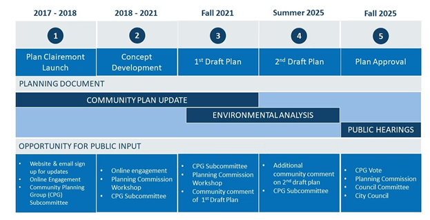
The Planning Process / Schedule
Project Completion: December 16, 2025
Plan update outreach:
- Plan Clairemont (or Clairemont Engaged) included a wide variety of opportunities for public input. In addition to meetings with the Clairemont Community Planning Group, webinars, pop-up outreach events, key stakeholder interviews, online surveys, and meetings with other community groups allowed for a variety of public input opportunities throughout the planning process. The community engagement effort helped inform the land use, mobility, and public space concepts that were incorporated in the Clairemont Community Plan.
Supporting Documents & Materials
Adopted Clairemont Community Plan & Associated Documents
On December 16, 2025, the San Diego City Council approved the updated Clairemont Community Plan and associated documents.
The Final Community Plan Summary of Changes Report summarizes the changes made to the Clairemont Community Plan.
The Final Mobility Technical Report provides a mobility analysis of the proposed mobility improvements identified in the Clairemont Community Plan Update.
The Addendum to the Final Program Environmental Impact Report Sch. No. 2021070359 for the Clairemont Plan Update (PEIR), analyzes the environmental impacts that could occur if the plan is implemented and identifies any feasible mitigation measures or alternatives to reduce any environmental impacts.
The Zoning Map illustrates the areas that will be rezoned to implement the land use map of the draft Clairemont Community Plan Update.
The City Planning Department accepted Comments from the Clairemont Community Planning Group which were reviewed and incorporated into the final plan.
The Rose Canyon/Creek Industrial District Land Use Compatibility Analysis for the Clairemont Community Plan Update.
The Community Enhancement Overlay Zone Diagram illustrates the areas that were included in the overlay zone as proposed by the Clairemont Community Plan Update. The areas are subject to the implementing regulations contained in the Municipal Code (§13.0216).
The Clairemont Height Overlay Zone which illustrates maximum height limits in the Clairemont Community Planning Area.
Draft Clairemont Community Plan Associated Documents
Draft Clairemont Community Plan Implementation Regulations (Updated Oct. 2025)
[CT2] Draft Clairemont Height Overlay Zone Amendment (Updated Nov. 2025)
Draft Clairemont Community Enhancement Overlay Zone Map (Updated Oct. 2025)
Draft Clairemont Community Plan Land Use and Zoning Table (Updated Oct. 2025)
Draft Clairemont Community Plan Environmental Review Memo
Clairemont Community Planning Group Comment Letter (Oct. 2025)
Second Draft Clairemont Community Plan Update
The August 2025 Second Draft Clairemont Community Plan Update balances a variety of feedback received on the first draft and Citywide objectives identified in the General Plan.
The Draft Summary of Implementation Regulations and changes to the Clairemont Height Limit Overlay to establish a framework to guide future development within the Clairemont community.
The Clairemont Community Planning Group comment letter provided on October 9, 2025 relating to the Second Draft Clairemont CPU.
The City Planning Department provided an overview of the Second Draft Clairemont Community Plan at the Project Review Subcommittee of the Clairemont Community Planning Group in August 2025.
- Review a Summary of Changes Between the First and Second Draft
- Review a Summary of Policy Changes Between the First and Second Draft
- Review a Summary of Supplemental Development Regulations between the First and Second Draft
- View Frequently Asked Questions
- View Second Draft Orientation Presentation provided to Project Review Subcommittee on August 4, 2025
- Draft Clairemont Community Plan Environmental Review Memo
- Draft Clairemont Community Plan Mobility Technical Report
- Draft Clairemont Community Plan Implementation Regulations Summary
- Draft Clairemont Community Plan Rezone Map (C-Sheet)
- Draft Clairemont Community Enhancement Overlay Zone (C-Sheet)
- Draft Clairemont Height Limit Overlay (C-Sheet)
- Draft Clairemont Community Plan Land-Use Zoning Table
- Flyer for Second Draft Clairemont Community Plan
Community Discussion Draft (January 2020)
The Community Discussion Draft a preliminary draft of the update to the Clairemont Community Plan.
Planning Commission Hearings Draft
Hearings Draft Clairemont Community Plan
Draft Implementation Regulations
Draft Clairemont Height Overlay Zone Map
- View Frequently Asked Questions
- Review a Summary of Changes Between the First, Second, and Hearings Drafts of the Clairemont Community Plan
- Review a Summary of Policy Changes Between the First, Second, and Hearings Drafts of the Clairemont Community Plan
- Draft Clairemont Community Plan Rezone Map (Updated Oct. 2025)
- Draft Clairemont Height Limit Overlay Zone Amendment Map (Updated Oct. 2025)
- Draft Clairemont Height Overlay Zone Amendment (Updated Oct. 2025)
- Draft Clairemont Community Enhancement Overlay Zone (Updated Oct. 2025)
- Draft Clairemont Community Plan Land Use and Zoning Table (Updated Oct. 2025
- Draft Clairemont Community Plan Environmental Review Memo
- Addendum to Program Environmental Impact Report Sch. No. 2021070359
- Draft Clairemont Community Plan Mobility Technical Report (Updated Oct. 2025)
- Historic Context Statement (Sept. 2025)
- Clairemont Community Planning Group Comment Letter (Oct. 2025)
Additional Documents and Meeting Materials
The Existing Conditions Map Atlas provided information on existing conditions in the Clairemont Community Planning Area and served as a baseline for the update of the plan (January 2018).
The Mobility Existing Conditions Report and Appendices provided information on existing mobility conditions in the Clairemont Community Planning Area.
The Existing Conditions and Opportunities Workshop presented information on current Land Use and Mobility conditions, and potential opportunities for the area (April 2017).
Summary Report from the Clairemont Community Plan Update Online Engagement Activity #1 – Guiding Principles and Community Identity (April 2017).
Summary Report from the Online Community Engagement Tool (OCET) and In-Person Workshop to gather input on the Draft Land Use Scenario (April 2019). An updated Draft Land Use Scenario was presented in September 2019.
The Community Plan Update Overview Presentation provided by the City of San Diego in October 2016 to introduce the Community Plan Update process. A fact sheet provided an introduction and overview of the Clairemont Community Plan Update.
Planning Commission Workshop Materials
The Planning Commission weighed in on the Clairemont Community Plan Update three times through different stages in the plan update process.
Clairemont Community Planning Group & Ad Hoc Subcommittee Documents
Draft Plan Review (1 of 3) – May 18, 2021
Draft Plan Review (2 of 3) – June 15, 2021
- Meeting Agenda
- Draft Plan: Urban Design Element, Public Facilities Element, Recreation Element Presentation
- Public Comments
Draft Plan Review (3 of 3) – July 13, 2021
Community Planning Group Meetings
- Meeting #1 – January 10, 2017
- Meeting #2 – February 14, 2017
- - Meeting #3 – March 14, 2017
- Meeting #4 – April 11, 2017
- - Meeting #5 – May 9, 2017
- - Meeting #7 – July 11, 2017
- - Meeting #8 – August 8, 2017
- - Meeting #10 – October 10, 2017
- - Meeting #11 – November 7, 2017
- - Meeting #12 – February 13, 2018
- - Meeting #13 – March 13, 2018
- - Meeting #14 – April 10, 2018
- Meeting #15 – May 8, 2018
- Meeting #16 – June 12, 2018
- Meeting #17 – July 10, 2018
- Meeting #18 – August 14, 2018
- Meeting #19 – September 11, 2018
- Meeting #20, February 12, 2019
- Meeting #21 – March 12, 2019
- Meeting #22 – April 9, 2019
- Meeting #23 – May 14, 2019
- Meeting #24 – May 29, 2019
- Meeting #25 – June 11, 2019
- Meeting #26 – July 9, 2019
- Meeting #27 – September 5, 2019
- Meeting #28 – October 8, 2019
- Meeting #29 – November 7,2019
- Meeting #30 – January 14, 2020
- Meeting #31 – February 11, 2020
- Meeting #32 – March 10, 2020
Balboa Avenue Specific Plan
On December 17, 2021, the California Coastal Commission certified the City of San Diego Local Coastal Program Amendment No. LCP-6-SAN-19-0165-3 Balboa Avenue Station Specific Plan.
Visual Simulation of the Proposed Pedestrian and Bicycle Improvements Accessing the Balboa Avenue Trolley Station
Rezone Map
FINAL Program Environmental Impact Report (PEIR)
Morena Corridor Specific Plan
On September 10, 2019, the City Council adopted the Morena Corridor Specific Plan. A copy of the final approved Specific Plan is now available.
The City has evaluated and provided recommendations for the areas adjacent to the Mid-Coast trolley stations at Tecolote Road and Clairemont Drive within the Clairemont Mesa and Linda Vista community planning areas. The recommendations address the future form of development in light of the introduction of the Mid-Coast Light Rail Transit (LRT) Trolley extension. In addition to land use and urban design recommendations, mobility improvements throughout the area have been identified for bicyclists, pedestrians, vehicles, and transit users.
The Morena Corridor Specific Plan builds upon the technical analysis and recommendations prepared and extensive public input received from the study. The specific plan provides policies and recommendations that address land use, mobility, urban design, recreation, and conservation to enhance the corridor.
The approved zoning map can be viewed from the link below:
Final Program Environmental Impact Report
The Final Program Environmental Impact Report (PEIR) for the Morena Corridor Specific Plan was released on Friday, Feb. 1, 2019. The Final PEIR and associated technical appendices can be accessed in the Final CEQA Documents web page.
Previous Drafts
July 2019 DRAFT Morena Corridor Specific Plan
January 2019 - DRAFT Morena Corridor Specific Plan
Draft August 2018 Morena Corridor Specific Plan
Draft July 2017 Morena Corridor Specific Plan
Linda Vista Meeting Presentations
Meeting #1 -Introduction - PowerPoint Presentation
Meeting #2 -Mobility - PowerPoint Presentation
Meeting #3 -Land Use - PowerPoint Presentation
Meeting #4 -Mobility - PowerPoint Presentation
Meeting #5 –Land Use - PowerPoint Presentation
Meeting #6 -Urban Design -PowerPoint Presentation
Meeting #7 – Specific Plan Overview and Recommendations
Meeting #8 – Specific Plan Recommendations
Meeting #9 – Final Draft Specific Plan Overview
Visual Simulation of the Proposed Roadway Network within the Morena Boulevard Station Area
Clairemont Community Planning Group Ad Hoc Subcommittee
- Meeting #1 -Introduction -PowerPoint Presentation
- Meeting #1 Powerpoint Presentation
- Meeting #2 PowerPoint Presentation
- Meeting #2 -Mobility -PowerPoint Presentation
- Meeting #2 Summary Notes
- Meeting #3 PowerPoint Presentation
- Meeting #3 -Land Use -PowerPoint Presentation
- Meeting #3 Summary Notes
- Morena #4 PowerPoint Presentation
- Morena #4 Summary Notes
- Meeting #5 Powerpoint Presentation
- Meeting #5 Summary Notes
- Meeting #6 PowerPoint Presentation
- Meeting #7 PowerPoint Presentation
- Meeting #8 PowerPoint Presentation
- Meeting #9 PowerPoint Presentation
- Meeting #10 PowerPoint Presentation
- Meeting #11 PowerPoint Presentation
- Meeting #12 PowerPoint Presentation
- Meeting #13 PowerPoint Presentation
- Meeting #14 PowerPoint Presentation
- Meeting #15 PowerPoint Presentation
- Meeting #16 PowerPoint Presentation
- Meeting #17 PowerPoint Presentation
- Meeting #18 PowerPoint Presentation
MORENA CORRIDOR SPECIFIC PLAN ONLINE FORUM
We encourage you to register for the Morena Corridor Specific Plan Online Forum. This interactive, online forum allows the community to provide feedback on topics that will inform the specific plan process. By registering, you will receive announcements and updates.
Previous Study Documents
Morena Boulevard Station Area Planning Study (PDF)
Appendices:
- Appendix A – Community Outreach Materials (PDF)
- Appendix B – Existing Conditions Materials (PDF)
- Appendix C – Existing Conditions Traffic Analysis (PDF)
- Appendix D – Land Use Support Materials (PDF)
- Appendix E – Mobility Alternatives Support Materials (PDF)
- Appendix F – Financial Feasibility Analysis (PDF)
Contact Us
For questions or comments regarding the Morena Corridor Specific Plan, please contact:
Marlon Pangilinan, Senior Planner, at mpangilinan@sandiego.gov or at 619-235-5293
1989 Clairemont Area Community Plan
The City Council adopted the 1989 Clairemont Community Plan on September 26, 1989.