The San Diego Seismic Safety Study
The San Diego Seismic Safety Study is a series of maps that indicate the likely geologic hazards throughout the city. These maps may be used to evaluate the relative risk within a region or to determine if a geotechnical report is required for development or building permits.
The California Department of Conservation continuously updates the Alquist-Priolo Earthquake Fault Zones (City of San Diego - Geologic Hazard Category 11) within the State of California.
For the most up-to-date limits of the Alquist-Priolo Earthquake Fault Zone, please refer to the Earthquake Hazard Zone map.
These maps do not furnish site-specific information and should be used only as a guide when evaluating risk. They are intended to be an indicator of what to expect at your site and provide general geologic hazard information.
Geologic Hazards and Faults Maps
Click a grid tile on the map below. After the PDF opens, you can zoom in to find a specific parcel and print a close-up view.
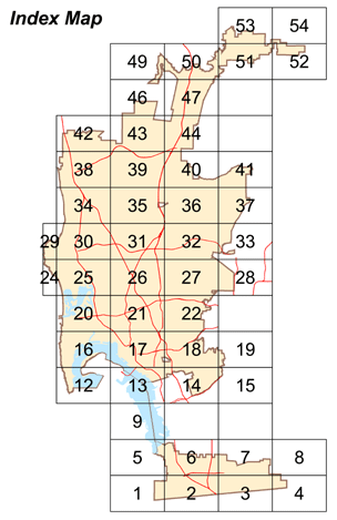
- Grid 1
- Grid 2
- Grid 3
- Grid 4
- Grid 5
- Grid 6
- Grid 7
- Grid 8
- Grid 9
- Grid 12
- Grid 13
- Grid 14
- Grid 15
- Grid 16
- Grid 17
- Grid 18
- Grid 19
- Grid 20
- Grid 21
- Grid 22
- Grid 24
- Grid 25
- Grid 26
- Grid 27
- Grid 28
- Grid 29
- Grid 30
- Grid 31
- Grid 32
- Grid 33
- Grid 34
- Grid 35
- Grid 36
- Grid 37
- Grid 38
- Grid 39
- Grid 40
- Grid 41
- Grid 42
- Grid 43
- Grid 44
- Grid 46
- Grid 47
- Grid 49
- Grid 50
- Grid 51
- Grid 52
- Grid 53
- Grid 54
Table 145.1803 (1) Required Geotechnical Investigation
Type of Hazard | Geologic Hazard Category | Building, Structure, and Facility Class |
|---|---|---|
| Fault Zones/Ground Rupture | 11, 12, 13 | A, B, C, D |
Landslides/Potential Slope Instability | 21, 22 | A, B, C, D |
23, 24, 25, 26, 27 | A, B, C | |
| Liquefaction/Potential Ground Failure | 31, 32 | A, B, C, D |
Coastal Bluff Stability | 41, 42, 43 | A, B, C, D |
44, 45, 46, 47, 48 | A, B | |
All Other Terrain | 54 | A, B, C |
52, 53 | A, B | |
51.55 | A |