Eastern Area - Previous Planning Efforts, Studies and Reports
Chollas Triangle Master Plan
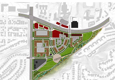
Chollas Triangle is an approximately 43-acre site within the Eastern Area and is bounded by 54th Street to the west, Chollas Creek to the south and east, and University Avenue to the north. The City, working with the community, amended the Mid-City Communities Plan to provide specific land use, mobility, and urban design recommendations to encourage a mixed-use transit-oriented village supported by public/civic/park space, open space, and creek enhancements within the Chollas Triangle Site. Chollas Triangle is envisioned as a vibrant, mixed-use neighborhood center that celebrates Chollas Creek and promotes the use of multi-modal transportation along University Avenue and 54th Street.
Chollas Traingle Community Plan Amendment -Neighborhoods Element Section
Chollas Creek Enhancement Program
The City of San Diego is undertaking the Chollas Creek Enhancement Program as a key element in revitalizing this culturally-rich portion of the City. The goal is to create an open space system that lends identity to this area and provides a safe recreational and natural resource for the region.
Construction on two Pilot Projects for the Chollas Creek Enhancement Program has begun. Segment 2A is at the intersection of Market Street and Euclid Avenue and Segment 8 is adjacent to the intersection of South 38th and Alpha streets. The scope of this project includes the removal of concrete channels along the creek, restoration of native vegetation and the creation of a linear park type setting with the inclusion of a trail system and an educational / interpretive element. This project will transform these two sections of the creek and the surrounding areas into positive open space features that the community can be proud of.
- Chollas Creek Enhancement Program, adopted May 14, 2002
- Chollas Creek South Branch Implementation Program
Community Planning
Planning Department
9485 Aero Drive, M.S. 413
San Diego, CA 92123
619-235-5200
planning@sandiego.gov