How to Prepare a Site Plan and Vicinity Map
This Information Bulletin describes how to prepare a typical site plan and vicinity map for development projects. Plans submitted or reviewed for a construction permit may require a site plan.
I. Site Plan
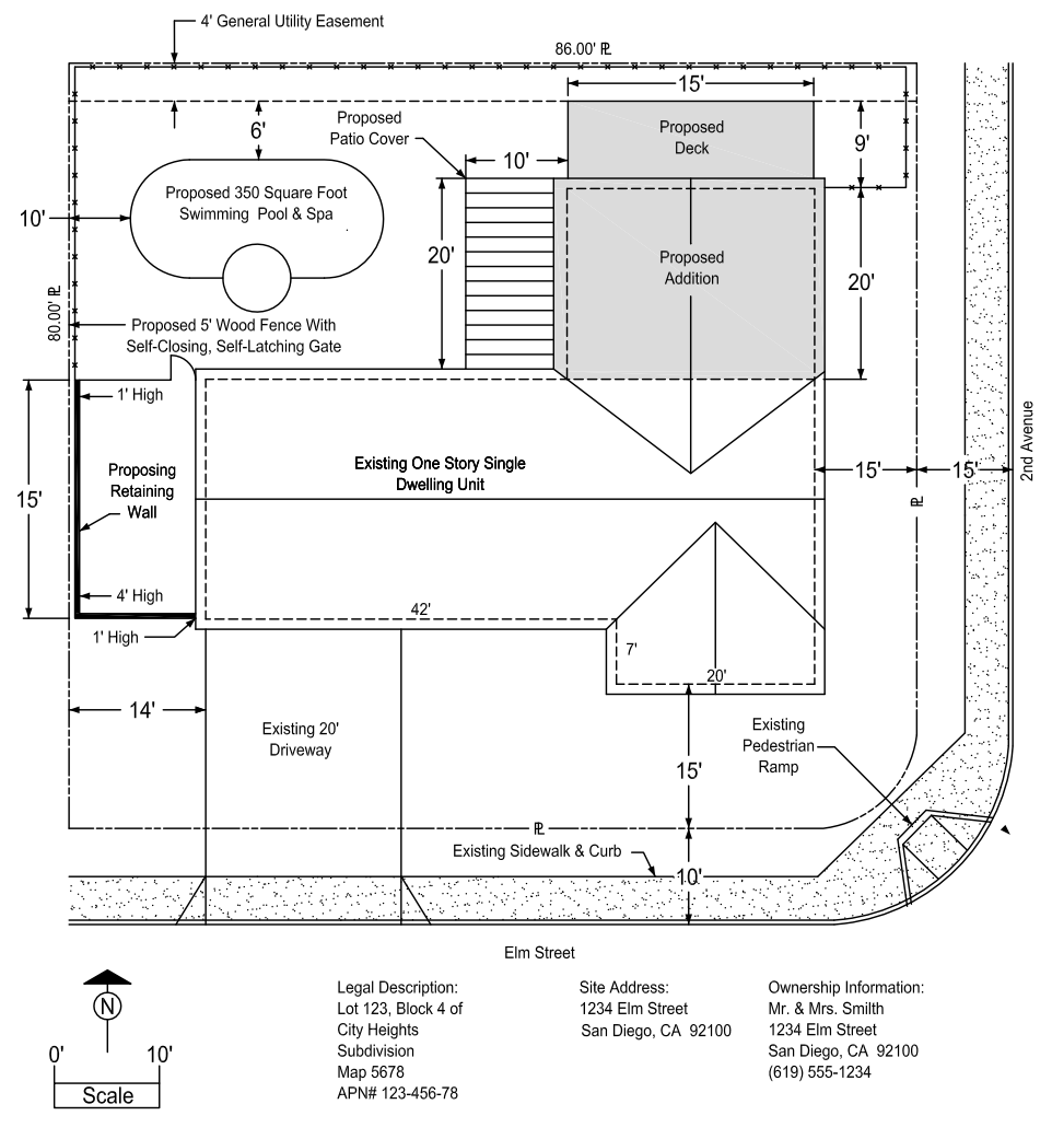
A site plan is a drawing that shows all property lines, lot lines, easements, public rights-of-way, buildings and structures located on the parcel of property (existing and new). For an example of a site plan and vicinity map, see Figures 1 and 2 below. These illustrations show several different types of additions and miscellaneous structures. Noted below is a list of items to be shown on the site plan:
- Scope of Work
A brief statement clearly describing the scope of work being proposed. - Property lines
Show all property lines/site boundaries, with dimensions. - Exterior Dimensions
Show dimensions of all existing and proposed buildings, additions and structures, with dimensions to property lines, dimensions between buildings and structures, and dimensions of architectural projections such as bay windows, fireplaces, etc. - Public Right-of-Way Dimensions
Curb to property line distance, or centerline of street to property line distance. Width of alley, if applicable, and type of paving. - Public Improvements
All existing and proposed curb, sidewalk, pedestrian ramps, driveways, etc. - Easements
Dimensions and locations of all recorded and proposed public and private easements. Obtaining a title report prior to site design and submitting it with the project is strongly recommended. While not required at initial submittal, a title report may be required during review. Failure to identify recorded easements on site plans during initial submittal will result in additional reviews, fees, construction changes and processing delays. Recorded private easement information is available from the County of San Diego. - Property Owner Information
Name, address and phone number of the property owner (s). - Site Address
Addresses associated with the project site. - Legal Description
Legal description and Assessor’s Parcel Number (APN) associated with the project site. - North Arrow
- Drawing Scale
- Brush Management Zones
For detailed information, refer to Brush Management Regulations, Bulletin #1: Brush Management Guide.
Figure 1: Typical Site Plan
II. Vicinity Map
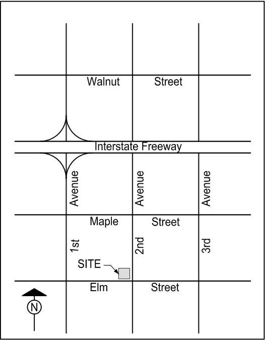
A vicinity map specifies the location of a proposed project in relation to major streets in the area. It is not required to have this map drawn to scale, but it should be proportional. Show at least two major cross streets and all other roadways leading to the site. A north arrow is also required. See Figure 2 below for an example.
Figure 2: Typical Vicinity Map
III. Records Information
Information regarding a project site, such as subdivision, right-of-way improvement, D-Sheets, previously approved discretionary and ministerial development, etc., may be obtained from the Records Section of DSD, located at 7650 Mission Valley Road. Please see Information Bulletin 110 for more detailed information about how to obtain records information.
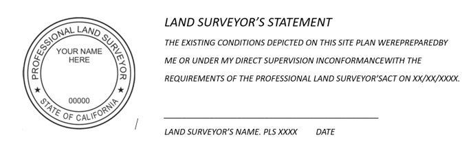
IV. When is a Surveyor's Signature and Stamp Required?
The preparation of a Site Plan showing property lines, easements and fixed works embraced within the practice of Civil Engineering per the California Business and Professions Code, Section 6731 shall be sealed, signed and dated by a person authorized to practice Land Surveying per the California Business and Professions Code Section 8700 et. seq.
V. Sample Required Licensed Land Surveyor Signature and Map
VI. Topographic Map and Boundary Survey Option
In lieu of a licensed Land Surveyor signing and stamping the site plan, a current Topographic Map and Boundary Survey with a Land Surveyor seal, signature and date showing the sites current condition may be provided as part of the plan set application, in addition to the project site plan. The Topographic Map and Boundary Survey must contain the detailed site information required for the review and processing of the project application.
If there is a Site Plan or Topographic Map from a previously approved permit that was signed, sealed and dated by a person authorized to practice land surveying and the current property improvement configuration match the improvements shown on the previous survey it can be used for the new permit. If there have been any changes to the project site since the previous survey (i.e. building modifications, additions, demolitions, development footprint changes), the previous survey cannot be used.
Previous Versions of this Information Bulletin
This section contains previous versions of this Information Bulletin by the last day they were effective.