


Lanes and Routes
As part of its Climate Action Plan to become a more sustainable City, the City of San Diego is focusing on creating more options for mobility. These efforts include expanding bike lanes, creating new bike routes and encouraging more people to choose bicycling. Below are information and links that can help bicyclists get around town
Bicycle Route Maps
The following bike maps are available to help you plan your ride:
-
San Diego Regional Bike Map - A paper copy of the San Diego Regional Bike Map is available at most local bike shops or at the San Diego Association of Governments (SANDAG) office located at 401 B St., Suite 800, San Diego, CA 92101.
Bicycle Facilities
There are four types of bicycle facilities identified in the California Highway Design Manual. Bike paths (Class I), bike lanes (Class II), bike routes (Class III) and cycle tracks (Class IV).
- Bike paths (Class I), also termed shared-use or multi-use paths, are paved right-of-way for exclusive use by bicyclists, pedestrians and those using non-motorized modes of travel. They are physically separated from vehicular traffic and can be constructed in roadway right-of-way or exclusive right-of-way. Bike paths provide critical connections in the City where roadways are absent or are not conducive to bicycle travel.
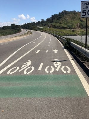
- Bike lanes (Class II) are defined by pavement striping and signage used to allocate a portion of a roadway for exclusive or preferential bicycle travel. Bike lanes are one-way facilities on either side of a roadway. Whenever possible, bike lanes should be enhanced with treatments that improve safety and connectivity by addressing site-specific issues, such as additional warning or wayfinding signage.
- Bike routes (Class III) provide shared use with motor vehicle traffic within the same travel lane. Designated by signs, bike routes provide continuity to other bike facilities or designate preferred routes through corridors with high demand. Whenever possible, bike routes should be enhanced with treatments that improve safety and connectivity, such as the use of "Sharrows" or shared lane markings to delineate that the road is a shared-use facility.
-
Sharrows
Sharrows are pavement markings that have been installed on City streets to provide guidance for both bicyclists and vehicles on roadways when sharing the road.
-
- Cycle tracks (Class IV), also referred to as protected bikeways, are exclusive bike facilities that combine the user experience of a separated path with the on-street infrastructure of a conventional bike lane. A cycle track is physically separated from motor traffic and distinct from the sidewalk. The separation maybe in the form of posts, parked cars or a combination of both. View this graphic to better understand proper use of these lanes:
 Using Protected Bikeways
Bicycle Detection at Signals
The City works to make sure bicycles are detected at intersections. ![]() Read more here about how to position your bike and what to do if detection does not occur.
Read more here about how to position your bike and what to do if detection does not occur.