Tierrasanta Community Plan
Adopted on July 27, 1982.
For a hard copy, contact City Clerk at 619-533-4000.

Includes agendas and minutes

About Tierrasanta
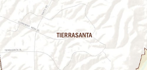
The Tierrasanta community encompasses approximately 11 square miles. The residential development of Tierrasanta began in 1960 when the federal government declared a portion of Camp Elliott, a Marine Corps training camp, as surplus. The City of San Diego adopted the Elliott Community Plan in 1962 to guide the initial acquisition of property for public uses, such as street rights-of-way. Much of the property was then privately developed from the 1970s through the 1990s based on the updated Elliott Community Plan, adopted in 1971. The military legacy of the community still exhibits a strong presence, such as Murphy Canyon Naval housing development, which accounts for approximately one-fifth of the total dwelling units in the planning area.
In 1976, the City adopted the boundaries for Mission Trails Regional Park, bisecting the Elliott planning area into two distinct sections. The park and the newly-developing section to the west were severed from the Elliott Community Plan, and a planning area was formed with the adoption of the Tierrasanta Community Plan in 1982. The more rugged, remote section east of Mission Trails Regional Park is now known as the East Elliott planning area and remains undeveloped.
The inclusion of extensive areas of natural open space has played a considerable role in shaping the form of development within Tierrasanta. Mission Trails Regional Park comprises approximately half of the planning area, and the San Diego River roughly forms the southerly boundary of the community. Canyon systems meander throughout the community, defining the transitions between individual development areas and interconnecting to the larger Mission Trails Regional Park canyon systems. The vast majority of developed land in Tierrasanta is devoted to residential uses, with several small commercial centers scattered throughout the community and light industrial near the intersection of Interstate 15 and state Route 52.
Tierrasanta is in Council District 7.
Community Planning
Planning Department
9485 Aero Drive, M.S. 413
San Diego, CA 92123
619-235-5200
planning@sandiego.gov