Designation of New Historic Districts
The Historic Preservation Planning section is responsible for the identification and designation of new historic districts consistent with City codes, policies and procedures.
This page provides information about historic districts, including what a historic district is and how it is processed, the responsibilities and benefits associated with owning property within a historic district, and our ongoing work program to evaluate and designate new historic districts.
Historic District Work Program Overview
With the adoption of the Community Plan Updates (CPUs) for North Park and Golden Hill in late 2016, the City Planning Department committed to the implementation of a work program to bring forward all 13 potential historic districts identified in the reconnaissance surveys that were prepared in support of the CPU efforts. The prioritization of the districts was developed in concert with the community and the Community Planning Groups. The schedule for processing the districts is as follows:
| Year | District Name | Community | Approximate Number of Properties | Date Designated |
|---|---|---|---|---|
| 2017 | Spalding Place | North Park | 14 | 7/27/2017 |
| 2017 | Valle Vista Terrace | North Park | 90 | 11/16/2017 |
| 2017 | South Park | Golden Hill | 407 | 10/26/2017 |
| 2018 | Melhorn & Son | North Park | 30 | 10/25/2018 |
| 2020 | Arizona Street Tract (Park Villas) | North Park | 48 | Found Ineligible |
| 2021 | Park Boulevard Residential | Uptown and North Park | 119 | |
| 2021 | Culverwell & Taggart's | Golden Hill | 245 | |
| 2021 | Kalmia Place | North Park | 20 | |
| 2021 | Altadena | North Park | 400 | |
| 2022 | 28th Street | North Park | 45 | |
| 2022 | St. Louis Heights | North Park | 135 | |
| 2023 | 30th Street Commercial | North Park | 128 | |
| 2023 | Wabash Mesa | North Park | 82 |
Historic Districts In Process
The Historic Preservation Planning section is processing four historic districts: the Park Boulevard Residential Historic District located in the North Park and Uptown communities, which was initially processed in 2018 before the effort was placed on hold; the Culverwell & Taggart's Historic District, located east of I-5 and north of Hwy-94 in the Golden Hill community; the Altadena Historic District, located between 32nd Street and Boundary Street around Redwood Street in the North Park community; and the Kalmia Place Historic District, located east of Balboa Park off of 29th Street in the North Park community.
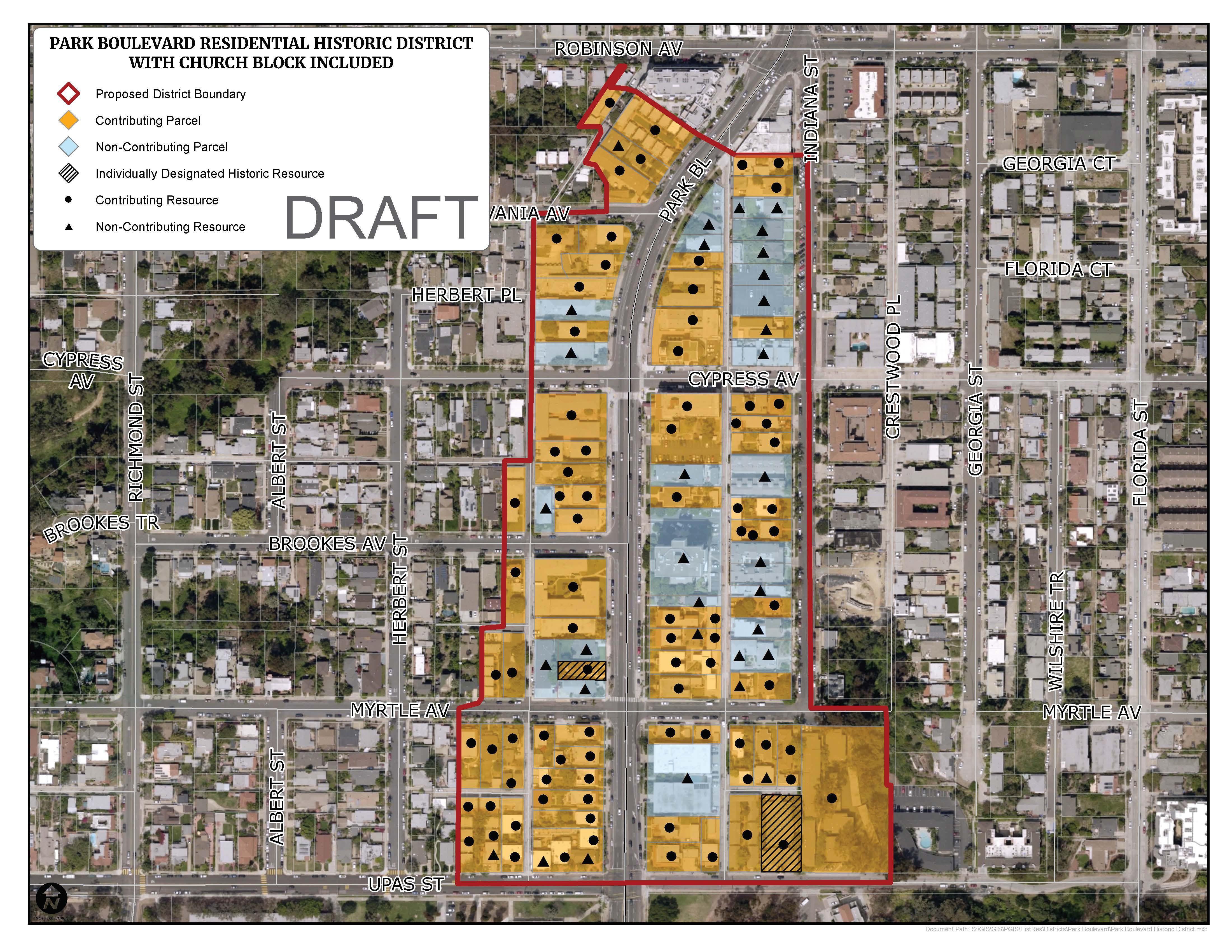
Park Boulevard Residential Historic District
Anchored by the multi-family flats and apartment buildings that line both sides of Park Boulevard north of Upas Street, the core of the district is contemporarily referred to as “Park Boulevard Apartment Row.” However, consistent with its early zoning designation, the district features a mix of single-family dwellings, duplexes, bungalow and cottage courts, garden court apartments, and six-pack / dingbat buildings.
- Significance Summary: The Park Boulevard Residential Historic District is significant under HRB Criterion A as a special element of San Diego’s historical, economic, and architectural development from 1900, when the area was initially platted as part of the University Heights expansion; through 1967, when the district was built-out and the character of new in-fill development began to reflect increased density allowances. The district is significant as a reflection of the area’s evolution from low density single-family uses to higher density multiple-family housing over several phases of development; and serves as a microcosm of the evolution of housing types and corresponding architectural styles in a first ring suburban neighborhood developed along a streetcar line.
- Boundary: The boundary generally includes all parcels fronting the east and west sides of Park Boulevard, generally between Upas Street (at the southern end) and Robinson Avenue (at the northern end), and generally extends west to the alley west of Park Boulevard and east to include the west side of Indiana Street.The district is comprised of 87 land parcels containing 119 resources, 86 of which are contributing and 33 of which are non-contributing.
Park Boulevard Residential Historic District Documents
The following documents provide information regarding the location and significance of the Park Boulevard Residential Historic District, and the individual properties within it.
- Map of the Proposed Park Boulevard Residential Historic District
- The History and Significance of the Park Boulevard Residential Historic District (Link to CHRID Database)
- Property-Specific Documentation for Each Property within the Park Boulevard Residential Historic District (Link to CHRID Database)
- Video tutorial on how to review the information for your property on how to review the information for your property.
Park Boulevard Residential Historic District Public Meetings and Hearings
Processing of the Park Boulevard Residential Historic District paused in 2018 in order to conduct additional outreach to property owners. Processing of the district will resume in 2020 with additional outreach, and processing will conclude within the calendar year. The following public meetings and hearings have occured or are scheduled to occur:
TBD 2020: Historical Resources Board First Hearing
TBD 2020: Historical Resources Board First Hearing
July 10th - July 30th 2018: Property Owner Polling Period
July 10, 2018: Property Owner Webinar at 12:00pm
Flyer for Park Boulevard Residential Historic District Workshop and Webinar
Recorded Webinar: View the recorded webinar presentation.
Help us improve our outreach! Please take a moment provide feedback on the content of the webinar through this quick online survey.
July 7, 2018: Property Owner Workshop at 10:00am at the Santa Fe Room (2150 Pan American Road West)
June 11, 2018: Historical Resources Board Policy Subcommittee Meeting
Meeting Results: At the Policy Subcommittee meeting the Subcommittee reviewed the nomination and did not recommend any alterations to the nomination. The nomination will proceed through the public review process as presented.
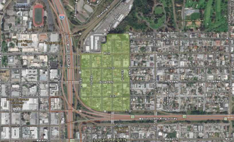
Culverwell & Taggart's Historic District
The Culverwell and Taggart’s Historic District consists of approximately 245 parcels, including 19 individually designated historic resources. Developed largely between 1869 and circa 1945, this district is potentially eligible under HRB Criteria A and C.
- Significance Summary: The significance statement for the Culverwell & Taggart's Historic District is currently in development.
- Boundary: The preliminary boundary for the Culverwell & Taggart's Historic District has been identified as Russ Boulevard to the north, 24th Street to the East, F Street to the south and 19th Street to the west. This area is currently under evaluation.
Culverwell & Taggart's Historic District Documents
The following documents provide information regarding the location and significance of the Culverwell & Taggart's Historic District, and the individual properties within it.
Culverwell & Taggart's Historic District Public Meetings and Hearings
Dates for public meetings and hearings will be posted here once determined, along with supporting information. Check back for updates.
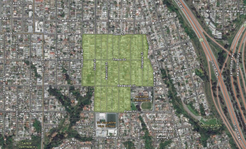
Altadena Historic District
The Altadena Historic District consists of approximately 400 parcels. Developed largely between circa 1907 and circa 1945, this district is potentially eligible under HRB Criteria A and C.
- Significance Summary: The significance statement for the Altadena Historic District is currently in development.
- Boundary: The preliminary boundary for the Altadena Historic District has been identified roughly as Upas Street to the north, McKinley Street Street to the east, Palm Street to the south and the alley between 32nd Street Herman Avenue to the west. This area is currently under evaluation.
Altadena Historic District Documents
The documents for the Altadena Historic District are currently in development. Check back for updates.
Altadena Historic District Public Meetings and Hearings
Dates for public meetings and hearings will be posted here once determined, along with supporting information. Check back for updates.
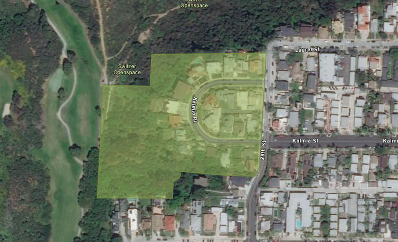
Kalmia Place Historic District
The Kalmia Place Historic District consists of 22 potential resources on 23 parcels. Developed largely between circa 1923 and circa 1959, this district is potentially eligible under HRB Criteria A and C.
- Significance Summary: The significance statement for the Kalmia Place Historic District is currently in development.
- Boundary: The preliminary boundary for the Kalmia Place Historic District has been identified roughly as the properties fronting onto Kalmia Place, west of 29th Street. This area is currently under evaluation.
Kalmia Place Historic District Documents
The documents for the Kalmia Place Historic District are currently in development. Check back for updates.
Kalmia Place Historic District Public Meetings and Hearings
Dates for public meetings and hearings will be posted here once determined, along with supporting information. Check back for updates.
Frequently Asked Questions
Detailed answers to the most common questions regarding historic district designation can be found here. If your question is not answered in the following links and documents, please email your question to historicplanning@sandiego.gov.
What are Historic Districts and How are They Designated?
A historic district is defined by the City’s Municipal Code as “a significant concentration, linkage, or continuity of sites, buildings, structures, or objects that are united historically, geographically, or aesthetically by plan or physical development and that have a special character, historical interest, cultural or aesthetic value, or that represents one or more architectural periods or styles in the history and development of the City.”
In other words, a historic district is a geographically defined concentration of resources – typically buildings – that come together to collectively convey a shared significance under one or more of the City’s designation criteria. Individual buildings within the boundary of the historic district may or may not be significant in their own right, but much like pieces of a puzzle these properties come together to paint a picture and tell an important story about our City’s past.
Historic Districts are designated through a public process that includes posting of detailed information on the City's website; workshops and webinars for property owners; and a series of noticed hearings with the Historical Resources Board and their Policy Subcommittee. Detailed information regarding the historic district designation process can be found using the buttons below.
What are the Benefits Associated with Historic Districts?
The indirect benefits for all properties include increased property values resulting from the desirable nature of historic districts, as well as preservation of the quality and characteristics that draw people to live in and visit the district.
Direct benefits available to contributing resources include allowances to deviate from zoning regulations such as setbacks by-right in order to allow new development while preserving the resource; Conditional Use Permits to allow adaptive reuse of historic building; use of the State Historic Building Code, which provides some flexibility from building code requirements to allow preservation of significant historic features; and the Mills Act, which provides a property tax reduction.
What are the Responsibilities Associated with Historic Districts?
The primary responsibility associated with a historic district are to maintain the property in accordance with the U.S. Secretary of the Interior's Standards for the Treatment of Historic Properties, and to obtain approval for maintenance, restoration, or alteration efforts prior to purchasing materials or undertaking work.
While some property owners may be concerned about additional City review of improvements, it is important to note that most improvements and alterations require City permits, even without historic district designation. Although historic district designation will require review of improvements that would not otherwise require a permit, the historic review occurs concurrently with all other approvals and is not a separate step in the process. Additionally, Historical Resources staff at the City's Development Services Department is available by appointment to advise on improvements under consideration, which can avoid possible delays during permit processing.
More information regarding City permit requirements and the historic review and approval process can be found in the following documents:
Strategic Plan Priority Areas of Focus
This program focuses on the following priority areas of the Strategic Plan:
Protect & Enrich Every Neighborhood
Identifies and protects geographically concentrated resources that tell a story important to the architectural, historical and/or cultural history of the city.
Contributes to creating a sense of place and a destination and assists in the revitalization of neighborhoods.
Champion Sustainability
Supports adaptive reuse of existing building stock through repair of quality materials.
(Updated May 2024)
Initiatives & Ongoing Work
Planning Department
9485 Aero Drive, M.S. 413
San Diego, CA 92123
619-235-5200
planning@sandiego.gov