


Open Space Parks
Explore over 28,000 acres of open space park land.
Review park rules and plan for the weather before starting your trip.
Where can I find Open Space Park maps?
Explore our open space parks
Open Space Trail Maps
Find trail maps for San Diego’s open space parks, preserves, and canyons. Choose a destination below to open its map.
Not sure which park or canyon to visit? Start with the citywide overview map.
Browse trail maps
Maps are listed alphabetically. Save your map before heading out; mobile coverage may vary.
29 trail maps
- 32nd Street CanyonPDF
- 47th Street CanyonPDF
- Black Mountain Open Space ParkPDF
- Carmel Mountain PreservePDF
- Chollas ParkwayPDF
- Crest CanyonPDF
- Del Mar Mesa PreservePDF
- Emerald Hills CanyonPDF
- Gonzales CanyonPDF
- Juniper CanyonPDF
- Los Peñasquitos Canyon PreservePDF
- Manzanita CanyonPDF
- Maple CanyonPDF
- Marian Bear Memorial ParkPDF
- Mission Trails Regional ParkPDF
- Mission Valley PreservePDF
- Mt. WoodsonPDF
- Navajo CanyonPDF
- Otay Valley Regional ParkPDF
- Pottery CanyonPDF
- Rancho Mission CanyonPDF
- Rose Canyon Open Space ParkPDF
- Ruffin Canyon & Sandrock CanyonPDF
- Sabre SpringsPDF
- San Pasqual / Clevenger CanyonPDF
- Swan CanyonPDF
- Switzer CanyonPDF
- Tecolote Canyon Natural ParkPDF
- West SycamorePDF
No matching maps. Try a shorter name or clear your search.
Mission Trails Regional Park is one of the largest urban parks west of the Mississippi. With more than 8,000 acres of open space, the park offers visitors the chance to participate in a wide variety of hikes and educational programs. It also includes Kumeyaay Campground.
Please Follow Citywide Park Rules
The City prioritizes the safety of those who visit these parks. It is important that these rules must be followed in order to achieve this goal. For more information on City Park Rules regarding pets, trash, general safety precautions, and more; please follow this link to view these rules in more detail.
To report suspected illegal activity, including transient encampments, encroachment onto City property or other maintenance needs, please call 858-538-8066. In an emergency, please call 9-1-1.
These three open-space parks comprise 1,500 acres and include trails for hiking, biking and bird watching in unique natural habitats. Click on the park link below to learn more.
Tecolote Canyon Natural Park and Nature Center
Please Follow Citywide Park Rules
The City prioritizes the safety of those who visit these parks. It is important that these rules must be followed in order to achieve this goal. For more information on City Park Rules regarding pets, trash, general safety precautions, and more; please follow this link to view these rules in more detail.
To report suspected illegal activity, including transient encampments, encroachment onto City property or other maintenance needs, please call 858-538-8066. In an emergency, please call 9-1-1.
Fifty-two acres of the San Diego River Park are known as the Mission Valley Preserve, which is under the supervision of the Park & Recreation Department's Tri-Canyon Park Rangers.
Please Follow Citywide Park Rules
The City prioritizes the safety of those who visit these parks. It is important that these rules must be followed in order to achieve this goal. For more information on City Park Rules regarding pets, trash, general safety precautions, and more; please follow this link to view these rules in more detail.
To report suspected illegal activity, including transient encampments, encroachment onto City property or other maintenance needs, please call 858-538-8066. In an emergency, please call 9-1-1.
Los Peñasquitos Canyon Preserve
A Resource Based Park
PLEASE NOTE: Trails may be closed due to flooding or damage. For up-to-date trail status, call the Park Ranger Office at 858-538-8066.
Los Peñasquitos (Spanish for "little cliffs") Canyon Preserve lies between Rancho Peñasquitos and Sorrento Hills to the north and Mira Mesa to the south. It stretches approximately 7 miles from the Interstates 5 and 805 merge to just east of Interstate 15. It encompasses some 4,000 acres of both Peñasquitos and Lopez Canyons. The Preserve is jointly owned and administered by the City and County of San Diego.
Los Peñasquitos Canyon Preserve attracts people with its natural beauty and abundant natural resources—both today and in the past. Native American history within the Preserve dates back as far as 7,000 years.
Remains of the prehistoric culture can still be found. More recently, the area was part of the first Mexican land grant in San Diego County. The historic Santa Maria de Los Peñasquitos Adobe (ca. 1823), operated by the County of San Diego (located at the east end of the Preserve off Black Mountain Road on Canyonside Park Driveway), has been restored, and tours are available for school groups and the public.
For more information, please call the County Park Rangers at 858-484-7504.
West End
At the west end of the preserve are the ruins of another adobe home, the El Cuervo (ca. 1857).
Los Peñasquitos Canyon and its tributary, Lopez Canyon, are characterized by varied natural resources. Evidence of the canyon's rich biodiversity includes over 500 plant species, more than 175 types of birds, and a great variety of reptiles, amphibians and mammals. Many of these species are rare or endangered and are protected within the Preserve.
For safety and the protection of the park's resources, please adhere to Park Rules & Regulations.
Features
The steep slopes, riparian stream corridors, flat mesa tops and grassy hillsides of the Preserve are made up of many different geologic formations and soil types. In conjunction with continually flowing water, the varying terrains and soil types form more than 14 habitat types and support a diverse collection of flora and fauna.
The scenery of the canyon includes:
- A waterfall cascading through volcanic rock;
- A streamside forest of giant California live oaks;
- Groves of majestic sycamore trees;
- A year-round stream populated by Pacific tree frogs, crayfish and largemouth bass;
- A freshwater marsh hosting a variety of aquatic birds, including great blue herons, egrets, mallard ducks and more;
- Mule deer, bobcat, coyote and raccoon are just a few of the mammals that can be observed in the Preserve.
Volunteering Opportunities
Volunteers are always welcome to help with the park's maintenance and operation. A Park Ranger assigned to the park area provides interpretive programs, public assistance, guidance, enforcement, and protection.
Please Follow Citywide Park Rules
The City prioritizes the safety of those who visit these parks. It is important that these rules must be followed in order to achieve this goal. For more information on City Park Rules regarding pets, trash, general safety precautions, and more; please follow this link to view these rules in more detail.
To report suspected illegal activity, including transient encampments, encroachment onto City property or other maintenance needs, please call 858-538-8066. In an emergency, please call 9-1-1.
Black Mountain Open Space Park
Natural Area
Black Mountain Open Space Park is a 2,352-acre natural area owned and managed by the City of San Diego. Located in Rancho Peñasquitos, it stretches between Camino del Sur, Peñasquitos Drive, Lusardi Creek, and Carmel Mountain Road. At the heart of the park is Black Mountain’s 1,554-foot summit, offering 360-degree views—from the ocean to the west, mountains to the north and east, and downtown San Diego to the south.
Visitors can reach the summit via a 2.5-mile dirt trail starting at Hilltop Community Park (9711 Oviedo Way). The trail climbs through scenic chaparral and coastal sage scrub landscapes. Utility vehicles occasionally use this road for maintenance at the summit.
Trails and Activities
Black Mountain features many trails for hiking, biking, and horseback riding, winding through hills, canyons, grasslands, and riparian (streamside) areas. Highlights include:
- Summit Trail – Moderate climb to the top with incredible views.
- Miner’s Ridge Loop – A peaceful 2.5-mile trail through chaparral on the north side, accessed off Black Mountain Road.
- Santaluz Trails – 10 miles of multi-use trails with a mix of easy to moderate routes, perfect for wildlife watchers.
Plants and Wildlife
The park is home to rich plant communities like chaparral and coastal sage scrub, plus grasslands and streamside trees like sycamores and willows. Common plants include manzanita, lemonade berry, California lilac, and black sage.
This variety of plants supports over 80 species of birds, plus mammals like mule deer, bobcats, and kangaroo rats. You may also spot Pacific chorus frogs, slender salamanders, and even a red-diamond rattlesnake.
Park Safety Rules
Reminder: All plants and animals in the park are protected. Please do not disturb or remove them.
- Park Rules
- Trail Map
- Information on the Black Mountain Open Space Park Natural Resources Management Plan
Volunteer Opportunities
The City of San Diego offers numerous volunteer opportunities to get involved in Black Mountain and other open space parks. Volunteer opportunities include cleanup projects, habitat restoration and trail maintenance projects. If people are interested, they are encouraged to attend the Black Mountain Open Space Parks Citizen Advisory Committee meetings held bi-monthly. For more information, please contact the park ranger staff at 858-538-8082.
To report suspected illegal activity, including transient encampments, encroachment onto City property or other maintenance needs, please call 858-538-8082. In an emergency, please call 9-1-1.
Open Space Canyons and Parkland Program
Open Space canyons are located throughout the City of San Diego and you may find one just beyond your own backyard. San Diego's canyons contain natural and cultural history unique to our region. For many communities these canyons are all that remain as undeveloped natural landscape. Canyons provide the citizens of San Diego with such benefits as scenic vistas, preservation of natural resources, outdoor recreation, and other benefits to health and well being.
The City of San Diego Park & Recreation Department's Open Space Division manages over 27,000 acres of open space, including open space canyons and parklands. Some 3,200 acres are citywide neighborhood canyons and parklands which are overseen by the Open Space Canyon Program staff.
The Open Space Division Canyon Program supports various "Friends of Canyons" groups by assisting with environmental education, canyon enhancement planning, weed management, trail maintenance, and kiosk installation. Park Rangers provide enforcement of City of San Diego municipal codes for park rules and regulations such as dog off leash and transient camp abatement.
To report suspected illegal activity including transient encampments, encroachment onto City property, or other maintenance needs, please call (619) 235-5262. In an emergency please call 9-1-1.
San Pasqual and Clevenger Canyon Open Space Park
The City of San Diego's Parks and Recreation Department manages and maintains the trails of San Pasqual and Clevenger Canyon, located east of the San Pasqual Valley. These trails offer great hiking and bird watching and are part of the San Dieguito River Park. Note that bicyclists and equestrians are not allowed.
History
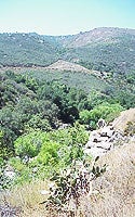
These trails were historically used by the Kumeyaay Indians for gathering food and medicinal plants, with historians estimating they collected over 12,000 native species. The Spanish settlement in 1769 drastically altered Kumeyaay life, introducing new practices and land claims for agriculture and cattle ranching, which became the region's primary economy.
After California was ceded to the U.S. in 1848, ranches were largely dissolved. Later, John Clevenger and his family established successful dairy and wheat farms in the San Pasqual Valley. In recent years, avocados and citrus have become profitable crops in the area.
Today
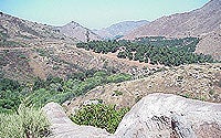
This area features steep canyons and peaks formed by a local fault line, characterized by granite bedrock and sandy loam from weathered granite. These unique soils support a southern mixed chaparral plant community, including chamise, ceanothus, and scrub oak. Rare Englemann Oaks provide food and shelter for abundant wildlife, which also consumes poison oak berries as a food source.
Hiking
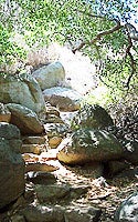
Both trailheads have paved parking, but lack restrooms and prohibit overnight camping. Hikers are advised to carry plenty of water due to hot canyon temperatures.
The south trailhead offers two shorter trails: A 1.5-mile west trail that gently climbs to an overlook of San Pasqual Valley. A 2.3-mile east trail that descends to a shaded ravine before climbing to a 1,755-foot summit, offering views of San Pasqual Valley.
The north trailhead is a more challenging 20-mile round trip offering more variety and solitude. However, it is poorly maintained with overgrown sections and lacks directional markers, making it difficult to follow. Hikers are advised to stop when the trail is no longer defined. Maps can be obtained by calling the Park Ranger's office.
Directions
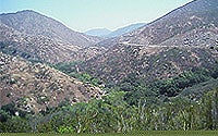
To get to San Pasqual and Clevenger Canyon from downtown San Diego, take state Route 163 north and continue onto Interstate 15 north. Exit at Via Rancho Parkway and travel east. Turn right on San Pasqual Valley Road and follow signs to the San Diego Zoo Safari Park. The southern trailhead is located 5.3 miles from San Diego Zoo Safari Park, and the northern tail head is 5.8 miles ahead. Parking lots are open from sunrise to sunset.
For more information on San Pasqual—Clevenger Canyon Open Space Park, call the Park Ranger's office at 858-538-8082.
Volunteering Opportunities
Volunteers are always welcome to help with the park's maintenance and operation. A Park Ranger assigned to the park area provides interpretive programs, public assistance, guidance, enforcement, and protection.
Please Follow Citywide Park Rules
The City prioritizes the safety of those who visit these parks. It is important that these rules must be followed in order to achieve this goal. For more information on City Park Rules regarding pets, trash, general safety precautions, and more; please follow this link to view these rules in more detail.
To report suspected illegal activity, including transient encampments, encroachment onto City property, or other maintenance needs, please call 858-538-8082. In an emergency, please call 9-1-1.
Otay Valley Regional Park (OVRP) is a multi-jurisdictional planning effort by the County of San Diego and the cities of San Diego and Chula Vista.
Please Follow Citywide Park Rules
The City prioritizes the safety of those who visit these parks. It is important that these rules must be followed in order to achieve this goal. For more information on City Park Rules regarding pets, trash, general safety precautions, and more; please follow this link to view these rules in more detail.
To report suspected illegal activity, including transient encampments, encroachment onto City property or other maintenance needs, please call 858-538-8066. In an emergency, please call 9-1-1.
Learn more about Open Space Canyons and Parklands